Using the Map Panel
The map panel has a number of advanced features that you can use to improve your use of the map.
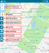
The map panel has the following icons:
- Zoom In and Out: Click the Plus (+) icon to zoom in and the Minus (-) to zoom out. You can also zoom in and out using your mouse wheel.
- Pegman: Enables you to switch the map to street view. See below.
- Get Directions: Click to obtain directions between 2 locations. Read more about getting directions.
- Calculate Distance: enables you to calculate the distance between 2 points on the map. Read more about calculating distance.
- Drop Pin: Enables you to create an incident by placing the drop pin on the incident location on the map. See below.
- Map Settings: Enables you to define the map settings as well as the type of map view. You can select to view the map from Street view, Hybrid (combination of street view and satellite view), and Satellite view.
- Trail Panel: Enables you to follow the trails of users.
-
Resource Monitor: Enables you to open the Resource Monitor and view the resources available at their different locations. Read more about resource monitor.
Moving and Zooming the Map
You can move the map to any position by clicking and holding your mouse (the cursors changes to a closed hand), and then dragging the map to the new position.
You can use the Plus (+) and Minus (-) icons to zoom in and out on the map. You can also zoom in and out using your mouse wheel.
Viewing the Map in Street View
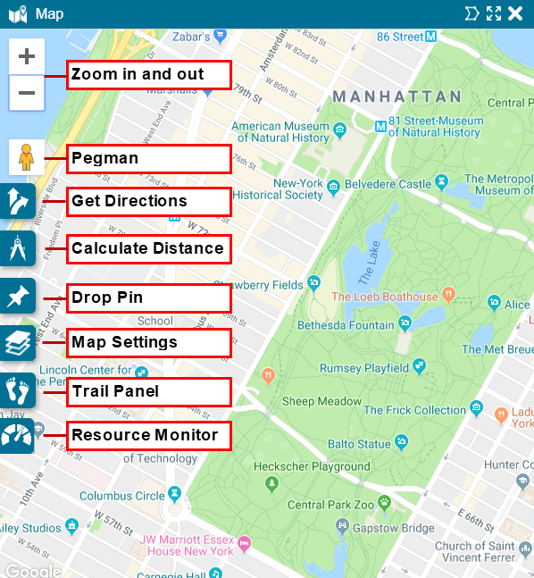
You can view the map in street view by dragging the Pegman to the location you want to view in street view.
After dragging the Pegman onto the map notice that:
- Areas with Street View imagery available are highlighted in blue
- Areas with indoor imagery available appear as orange dots on the map.
Unclick your mouse to drop Pegman on the map and your map changes to street view.
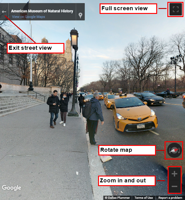
- To move down the road: Hover your cursor in the direction you want to travel. Your cursor becomes a circle. Click once to travel to the circle.
- To rotate the map: Click and drag your mouse in the direction you want to see, or click the compass to rotate the map in the required direction.
- To zoom in or out: Use your mouse wheel to zoom in and out on the map, or use the Plus (+) and Minus (-) icons to zoom in and out on the street view.
- To orient your Street View North: Click the compass icon.
- To toggle to full screen view: Click the icon on the top right of the map to expand to full screen view. Click Esc to return to normal view.
- To return to the map: Click the Exit Street View icon in the top left corner of the Map panel.